September 16 – Needles
We “took it easy” in the morning in Winslow, checking out the hotel in the daylight.
 |
| The entrance of La Posada |
We then moved down the road and found the corner of song fame ("Take It Easy" by the Eagles), complete with a statute of a guy standing on the corner and a flatbed Ford. There were souvenir stands on two of the remaining corners, one blaring Eagles tunes into the street. Just down from the corner, we found an art gallery/coffee shop for some coffee and pastries.
 |
| Standin' on the corner in Winslow, Arizona |
 |
| No girl, my lord, but there's a flatbed Ford |
 |
| One corner of the Standing on the Corner corner intersection |
 |
| Another corner of the Standing on the Corner corner intersection |
 |
| Another kind of tribute -- "Sleeping on the Corner in Winslow, Arizona" at Earl's 66 Motel |
We headed out of town around 9:30, driving mostly along I 40 until we came to Meteor Crater. To paraphrase one of our guide books, Arizona is about deserts and holes in the ground. The crater was one of those holes. We found ourselves very pleasantly surprised at the amount of time we spent (about 90 minutes) and the information on display.
The crater was created over 55,000 years ago. It was created by a meteorite over 150 feet in diameter. The crater is about 500 feet deep, over 2 miles in circumference and one mile in diameter. There could be over 20 football fields in the bottom of the crater and the games played on the fields could be watched by 2 million people if seats were set on the sides of the crater.
 |
| Meteor Crater |
 |
| Having fun in front of a big hole in the ground (note Martha's hat, which we bought in Santa Fe and about which a lady from Texas remarked that it was the nicest hat that she had ever seen) |
 |
| At the center of the crater floor, a fenced in area holds old mine equipment. An American flag and a 6 foot cut-out of an astronaut (to honor the fact that astronauts trained there for lunar exploration) appears in the lower right corner outside the fence. |
 |
| From the highest observation deck at Meteor Crater, 180 degrees from the crater shows a view of the San Francisco Mountains, with Flagstaff just below them. |
The crater sits on the land of one of the largest ranches in Arizona. The Double Bar T Ranch comprises over 300,000 acres. In the 1950’s the families that own the Double Bar T formed a corporation to run the concessions for the crater. Some of the staff working at the crater live there.
The crater experience includes a 30 minute guided tour (a ¼ mile hike along the rim), a 15 minute movie, a museum with numerous interactive and very well done exhibits and, of course, a gift shop.
The immediate way west from the crater had us stay mostly on I 40, with brief off-highway visits to two old trading post locations: Two Guns, with its concrete buildings in ruin, but still advertising “Mountain Lions”; and Twin Arrows, with its iconic structures that heralded the trading post there.
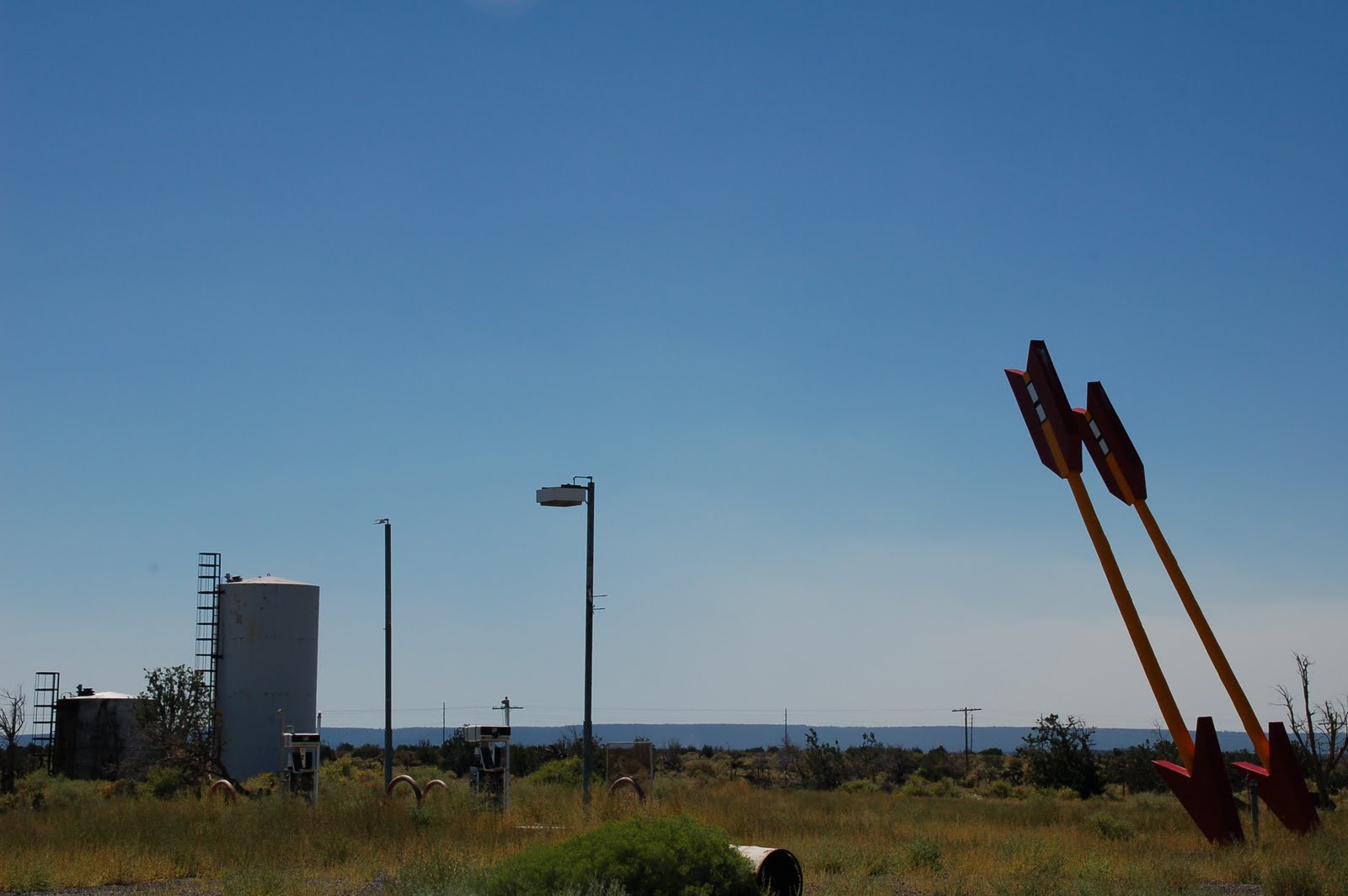 |
| Twin Arrows Trading Post iconic gigantic arrows |
Our first major departure from I 40 occurred at Winona, where the landscape changed appreciably. It went from flat desert and scrub to a forest. As we made our way west, through Winona and into and past Flagstaff, we went through two national forests, the Coconino and the Kaibab (the latter being part of the forest that straddles the Grand Canyon).
 |
| Remains of the Twin Arrows Trading Post (with "red state" commentary) |
At Flagstaff, we encountered our first major traffic since leaving Albuquerque. There were a number of interesting sights there. Among our favorites were the Western Hills Motel, the Dog Haus and Granny’s Closet, where we ate lunch (we split some honey BBQ wings).
 |
| Western Hills Motel and Restaurant sign in Flagstaff (not shown is its sign offering Vietnamese food) |
 |
| Lining up at the Dog Haus in Flagstaff |
 |
| Display outside of Granny's Closet in Flagstaff |
West of Flagstaff, we returned to I 40 for a long stretch until we reached Williams. At Williams, the landscape changed again. The dense forest had disappeared and there were smaller and more sparse pine trees.
Williams has the distinction of being home to the last part of Route 66 that was decommissioned. But you’d never know it. It had a two mile loop (one two lane street going west, another going east) through the center of town, with many thriving businesses and tourist attractions. One good sign (for the town) was that it took a few minutes for us to be able to back our ‘Stang out of a parking place because the through traffic was so regular.
 |
| The start of the business district in Williams, Arizona |
 |
| Cruisers Cafe 66 in Williams |
 |
| Pete's Gas Station Museum in Williams |
 |
| Turquoise Teepee in Williams |
From Williams, we went back onto I 40 only to get off I 40 at Ash Fork. Unlike Williams, Ash Fork did not fair well when Route 66 was decommissioned. There were a few sights remaining in town. Most notably was DeSoto Beauty Salon, upon which there is a life sized replica of a DeSoto.
 |
| DeSoto's Salon in Ash Fork, Arizona (Elvis at the wheel) |
 |
| Hi-Line Motel (closed) in Ash Fork |
A few miles after Ash Fork, we were on and then off I 40, and we would stay off I 40 for the longest stretch in quite some time. The road headed north and into what was clearly becoming canyon country. Gone were the flat desert vistas or the forests. Now, especially at Crookton Pass, we found ourselves driving between large craggy mountains.
From here until Kingman, we saw about half a dozen sets of Burma Shave signs. Here are a few that we wrote down:
Would be more fun
To travel by air
If we could put
Our signs up there
He tried to cross
As fast train neared
Death didn't draft him
He volunteered
The one who drives when
he's been drinking
Depends on you
To do his thinking
If daisies are
your favorite flower
Please keep pushing up
Those miles per hour
Cattle crossing
Means go slow
That old bull
Is some cow's beau
On this part of the road, we came across two of the “wildest” places that we’ve found thus far. The first was the town of Seligman, the former home of two brothers, Juan and Angel Delgadillo, who headed the Arizona Route 66 Association. (Both are recently deceased.) The Delgadillo brothers, just like the rest of the town, aggressively embraced their Route 66 heritage. Both also owned iconic business establishments in Seligman.
Juan owned the Snow Cap Drive In. He was known for his good humor and occasional playful pranks on customers. After his death, his family has carried on that tradition. The exterior of the building is a visual assault of gags. There are signs featuring fare such as “dead chicken” and “cheeseburgers with cheese.” The order window area is a tunnel of business cards and mementos from around the world. (In fact, the people who were ahead of us in line were from England.) Even ordering provided a small floor show, with nearly nonstop jokes and gags. For example, when the server asked the English folks whether they wanted some straws, he reached down and came back with a handful of straw. When he asked them if they wanted some mustard on their hot dogs, he squirted a bottle of mustard at them, from which erupted a short yellow string of fake mustard. When it was our turn to order, among other things, as he made change, the server asked David, “Do you have any cents?” To which David had to reply that he had “no sense.” The chocolate shake and root beer float that we ordered were good, too.
 |
| Snow Cap Drive In in Seligman, Arizona |
 |
| At the Snow Cap Drive In |
 |
| "The Facilities" behind the Snow Cap Drive In |
 |
| We weren't sorry at the Snow Cap Drive In |
 |
| What we got when we asked for a small chocolate shake and said "yes" to the question, "Do you want my card?" |
The gift shop owned by Angel and his wife Velma was just down the street. These were just two of many offbeat places to see in town.
 |
| Angel & Velma's Gift Shop, Visitor Center and Barbershop in Seligman |
 |
| The Rusty Bolt in Seligman (those are not real people) |
 |
| The Copper Cart Motel in Seligman |
 |
| The Roadkill Cafe in Seligman |
Leaving Seligman, we continued on the road, going north and west. We encountered Grand Canyon Caverns, a converted fall out shelter, now a tourist “attraction.” In this area, there was a motel, a bar, a restaurant, horseback riding stables and, of course, the “cavern.” Outside the cavern was a dinosaur, a remnant of when the attraction was called Dinosaur Caverns. When we got there, a cavern tour had just departed, which meant that we would have to wait 45 minutes for the next one. Because we knew that we were going to have some hairy driving ahead and because we knew that we had only about three hours of light left, we decided not to wait.
 |
| The entrance to the Grand Canyon Caverns (formerly, Dinosaur Caverns), a former fallout shelter |
The next town after the caverns was Peach Springs. Just west of that town, the road climbed and upon reaching the top revealed a spectacular view of the canyon country. According to our guide books, we were supposed to be able to see the Colorado River empty into Lake Meade, but we couldn’t see that. The view was great nevertheless.
As we traveled west, and into the Mojave Desert, the temperature started to climb. We had started the day at 73 in Winslow. When we got to the crater, it was in the mid-80’s. Now, it was in the high 90’s. By the time we hit our motel for the night, the temperature was 104.
There were some small towns along this part, including Hackberry which featured an unusual general store and a Tiki display to an RV park.
 |
| Hackberry General Store |
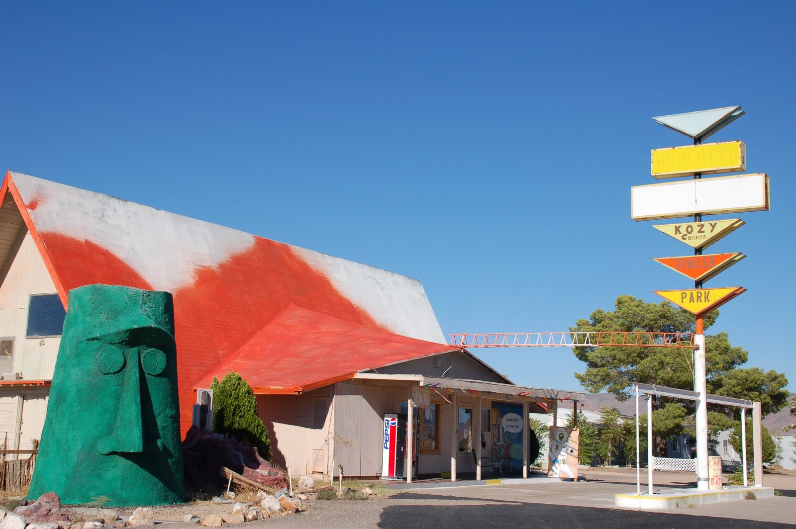 |
| A giant tiki stands guard by Kozy Corner Trailer Park west of Hackberry, Arizona |
The big town in this part of the Mother Road is Kingman, best known as the birthplace of Andy Devine, for whom part of Route 66 is named in that city.
The road between Ash Fork and Kingman was terrific. It was very well maintained and allowed us to make good time. That changed west of Kingman. The speed limit, which had been 65 in areas outside of the towns, had dropped to 45. But the road was in such terrible shape that going 45 was difficult. Fortunately, the road was very straight, leading us to the Black Mountains. There was no traffic, except for two or three vehicles that came the other way.
We then started to climb the Black Mountains, driving towards Sitgraves Pass. The road reminded us of other challenging drives, such as Going to the Sun Road in Glacier National Park or the road to Hana in Maui. The road twisted and turned and sat on the edge of a mountain side. Unlike those other roads, curbs and railings were missing, the only things on the outer edge of the road were reflector sticks. Martha reports that the views of the mountains from the road were great. David, the driver, was unable to appreciate the view until we came to Sitgraves Pass, which revealed another spectacular view.
Once over the pass, we went through Gold Road, where a gold mine still operates. Oatman, the second of our “wild” towns, was next. As our guide book put it, Oatman had ceased digging for gold and was now digging for tourist dollars. The town was comprised of two or three blocks of buildings designed to look like the old west. The town also featured wild burros which roamed the streets at will.
 |
| "Wild" burros in Oatman, Arizona |
 |
| The names of Oatman establishments play variations on the "burro'' theme |
 |
| Although one establishment got its name the old fashioned way |
One unusual feature of our day was that it seemed as if we were being followed by a group of French tourists. They were with us on our tour of Meteor Crater. They were at Granny’s Closet in Flagstaff for lunch. And they were walking around Kingman.
Driving the single street through Oatman was made difficult, not just because of the burros, but also because of the French tourists who didn’t seem to recognize that they were standing in the middle of a road.
 |
| Burros appropriately attacking French tourists in Oatman |
Oatman was located a ways up the Black Mountains. So the road down, though not as daunting as the road to Sitgraves Pass, still didn’t allow for high speed. The only thing worthwhile in this stretch was that it seemed to be heavily populated with roadrunners and jackrabbits, which darted across the road with regularity.
 |
| A roadrunner along the road west of Oatman |
Between 530 and 6, we reached to California border. We crossed the border on I 40 and the road deteriorated immediately. As soon as we could, we left I 40 and followed the historic Route 66 road into Needles.
From what we could tell, Needles is a fairly nondescript town, where our nondescript hotel (a Best Western) is located, next to a nondescript restaurant (Juicy's Route 66 River Cafe), where we ate our nondescript dinner.
P.S. As this post was being written, we also tried to do our laundry in the motel's landromat. When the machines broke down (fuses blew), the staff took our laundry and washed and dried it in the motel's machines, presenting the laundry, folded, to our room.
No comments:
Post a Comment