September 14 - Albuquerque
In keeping with the Santa Fe vibe, we started the morning on a very mellow note. We walked across a quiet road to the Nicholas Hacienda B&B for breakfast. A very low key guy informed us of what he was making for breakfast. The only word that we understood was "beans". Whatever was on the plate, and whatever it was called, it was good. While we had breakfast, we met the proprietor who had started in the B&B business over twenty years ago. For someone who runs two B&B's and a spa (called "Nirvana"), she had a lot going on.
 |
| The front entrance of the Madeline Inn with our room's windows shown on the second floor |
We were slow to get going. We wanted to complete yesterday's post (and get "caught up"). We left the Madeline about 10. It took us a little while to get out of Santa Fe (our EZ Guide, normally an unerring guide of the most minor detail in directions, failed us). The transition out of the middle of Santa Fe was interesting. We went from real adobe and idiosyncratic architecture and businesses to strip malls with ersatz adobe (our favorite was an "adobe" IHOP). Once free of suburban Santa Fe (which sounds like an oxymoron), we got to old road surrounded by desert with the mountains in the distance. We wanted to take a side trip to the Kasha-Katue Tent Rocks National Monument (reported to have some short hikes with great payoffs -- spectacular end of trail views), but as we turned down the 8 mile road to the Monument, we saw a sign that it was closed. So we got back on Route 66, alternating between parts of I 40 and side roads.
As we approached Albuquerque, Route 66 also became El Camino Royale. The road was well kept. Just before Albuquerque is Bernalillo (pronounced Burn-a-li-yo). In Bernalillo, we saw one attempt to cash in on the Route 66 glory.
 |
| Route 66 Gallery in Bernalillo, New Mexico |
Prior to 1937, going westward, Route 66 went up to Santa Fe and then down to Albuquerque. After 1937, the loop up to Santa Fe was eliminated and a more direct east-west route from Albuquerque to Tucumcari was established.
Once we got into Albuquerque proper (another oxymoron?) at a little after noon, we diverted over to the Indian Petroglyph National Monument to the west of Albuquerque's downtown. The Monument protects one of the largest sites of petroglyphs created by Indians and Spaniards between 400 and 700 years ago. There are two areas, Boca Negra Canyon and Riconada Canyon. Boca Negra Canyon has three fairly short trails: Mesa Point, Macaw and Cliff Base. The Mesa Point takes you up to the top of a mesa which is littered with volcanic rock. The petroglyphs appear in fairly large numbers throughout this area. The Macaw Trail took literally less than five minutes to travel and featured two petroglyphs of macaws (although we could only find one macaw petrogylph). The Cliff Base Trail continued with a fairly well concentrated display of petroglyphs. It took us around an hour to do the Boca Negra trails. The external thermometer in our car said 83, but it felt much hotter.
 |
| The Mesa Point Trail |
 |
| Sign on the Mesa Point Trail |
 |
| "Spainish Style" Cross |
The Riconada Canyon Trail is a 2.5 mile loop into a canyon. Going in, there were many petroglyphs to see. Going out, the trial was just a desert trail, albeit with lots of vegetation and some signs of wildlife (a desert wren, some lizards, and some kind of vole).
 |
| On the Riconada Canyon Trail |
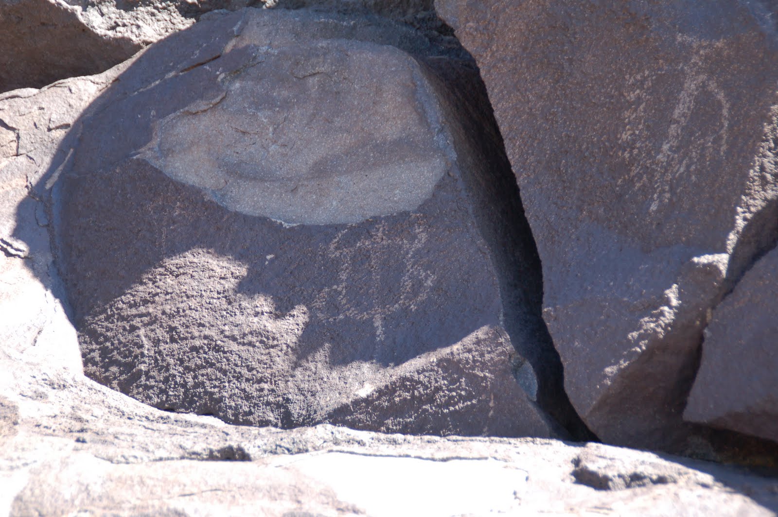
At the Boca Negra Canyon, we met a man who seemed to be using great care to take photographs -- with his cell phone. He told us that he was "trying to ascertain" what the petroglyphs meant. We pondered that for a while. As we were walking through the Riconada Canyon, it hit us: these drawings were really a comic strip about two guys, Petro and Glyphie, who liked to dress up, and play with snakes, deer and birds, and who sometimes got into big trouble. (Fans of "When Harry Met Sally" will understand this reference.) See our interpretations below.
 |
| They had a pet turtle and a pet bird |
 |
| Halloween outfit circa 1550 |
 |
| Chinese New Year 1575 |
 |
| Mardi Gras (year unknown) |
 |
| "Stuck in maze. Help!" |
We left the Monument a little before 3 and headed to find our lodgings for the night. The Los Poblanos is a complex of a "cultural center," a farm and an inn. The buildings were designed by famous architect John Guy Meems in the 1930's. When we arrived, we were told that our room was not yet available. So we wandered down Rio Grande Blvd. (one of the main roads in Albuquerque) to the Flying Star, a cafe with an attached bookstore. David had mulligatawny soup. Martha had a huge blueberry pancake. They both hit the spot.
At about 4, we returned to Los Poblanos. We thought that we were getting one of about seven of the older rooms in the Inn. When we arrived, we found out that we were slated for one of the "brand new rooms" in a new wing of the inn. They created the rooms to look like the old rooms, with a large four poster bed, hand carved beamed ceilings and a kiva fire place. Unfortunately, since we were literally the first people to stay in the buillding, much less the room, some "amenities" were missing -- like shades on some of the windows (including the one in the bathroom). Fortunately, David figured out how to use towels to cover up the windows without the blinds.
After we got our bags, we walked over to the farm and visited the farm shop. We learned that the farm was a cooperative, where people worked on the farm in return for the right to some of the harvest. We then showered (we were very sweaty from three hours of desert hikes) and then found the room for the "happy hour" spread: two bottles of wine and a plate of cheese. We met four people (three women and a guy) who worked for a company that helps credit unions have ATM machines. They were getting ready to do some training on Wednesday. They were all from Rancho Cucamonga, California. When we told them that we were going to drive through there, they let us know all the place that we "had" to see in that city.
Two glasses of wine (apiece) later, we headed off to "Old Town," an area of Albuquerque with Santa Fe aspirations. We found the Church Street Cafe, where we had lunch on our last visit to the town (about 15 years ago). We were seated in a new area which had been their outdoor patio, but now is an airy, high ceilinged room with large windows and interesting light fixtures and art. Our waitress was having a bad day (when she asked us how we were doing, we asked her the same and she started to cry). She rebounded nevertheless. We split a pitcher of some very fruity sangria. Martha had tacos (again!). David had chiles rellenos. Both were very good.
We started back to our car and a woman across the street starting yelling to Martha to come into her store and get 70 percent off. It was an offer that Martha couldn't refuse.
Damage done, we drove south on Rio Grande until we hit Central, which was the east-west path that Route 66 followed through the city. On Central, we headed east and saw some of the old glory of the Mother Road. The transition through town was notable. First, there was downtown. Then, there was the campus of the University of New Mexico (with cross streets named for other colleges -- Cornell, Stanford, Columbia, Vassar, to name a few), and then the businesses catering to the university students (first restaurants, then bars). This was followed by a Hispanic neighborhood, which transitioned into an Asian one. Suburban strip malls followed and then some more dispersed businesses.
 |
| Aztec Motel along Central Avenue in Albuquerque |
 |
| The renovated Century Theater |
 |
| The Hiway House Motel |
We then found I 40 and headed back west. At the Rio Grande exit, we headed north to our room for the night. We are vowing to get an early start tomorrow, given our very ambitious schedule.


No comments:
Post a Comment